
- Heracleion هيركيليون
عند عبور الطارق وطبقا للدراسات الجيولوجيه لطبقات الارض فمن المفترص ان تفقد الاسكندريه ثلاثون كيلو من الارض الي الجنوب تحت الماء
طبقات
الاسكندريه البحريه الجيواوجيه والساحل الشمالي مسنوده بنوايه لانها تتكون
من من طبقات جيولوجيه صغيره فوق بعضها البعض وتقع الطبقه الاوربيه تحتها ،
وكذلك الاطلنطيه ،و في حاله تصدع الشق الاطلنطي سينخفض سطح البحر المتوسط
لانه سيفقد في هذه الحاله ماكان مسنودا اليه ! وهو السيناريو المتوقع جدا
ونصيحتي لسكان الاسكندريه والسواحل الشماليه لمصر بالابتعاد عنها واللجوء لمناطق بعيده عن الساحل والافضل ان تكون مرتفعه
وستغرق منطقه الدلتا بالكامل حتي مائه وستون كيلو للجنوب حتي تملآ المياه شوارع القاهره كما سيملآ الماء شوارع الكوفه والنجف
وهذه ليست المره الاولي التي تفقد فيه الاسكندريه ارتفاعها عن سطح البحر. فقد تم اكتشاف مدن كامله وحتي اكثر من ثلاثون كياو داخل البحر ، تحت الماء قد غرقت في اوقات مختلفه اخرها منذ ١٢٠٠ سنه
http://wbaseem.wordpress.com/2013/05/17/تفسير-مختلف-لسوره-الطارق-،الكوكب-الاح
وستصبح
افريقيا هي الملاذ الامن قبل وبعد التغير القطبي لانها تتكون من قطعه
واحده من الجرانيت الصلب ، حيث ستبدآ هجره الكثير من دول اوروبا وغرب
افريقيا الي مصر وستصبح اثيوبيا من الدول العظمي لما سيؤل اليه موقعها
الجغرافي الجديد واتخاذ العديد من الدول المتقدمه اثيوبيا كقاعده لهم.
http://wbaseem.wordpress.com/2013/06/17/المهدي-المنتظر-والنحم-المذنب-الاحمر-،/
الخبر
وكشف وفيق عن خطط لتوطين نحو8 ملايين
مواطن في الساحل الشمالي في اطار المخطط القومي الشامل للتنمية العمرانية ،
وإعادة توزيع التنمية والسكان بما يعيد التوازن الطبيعي للسكان وعلاقتهم
بالأرض والموارد
HeracleionThonis-Heracleion (the Egyptian and Greek names of the city) is a city lost between legend and reality. Before the foundation of Alexandria in 331 BC, the city knew glorious times as the obligatory port of entry to Eg...ypt for all ships coming from the Greek world. It had also a religious importance because of the temple of Amun, which played an important role in rites associated with dynasty continuity. The city was founded probably around the 8th century BC, underwent diverse natural catastrophes, and finally sunk entirely into the depths of the Mediterranean in the 8th century AD.
Prior to its discovery in 2000 by the IEASM, no trace of Thonis-Heracleion had been found. Its name was almost razed from the memory of mankind, only preserved in ancient classic texts and rare inscriptions found on land by archaeologists. The Greek historian Herodotus (5th century BC) tells us of a great temple that was built where the famous hero Herakles first set foot on to Egypt. He also reports of Helen’s visit to Heracleion with her lover Paris before the Trojan War. More than four centuries after Herodotus’ visit to Egypt, the geographer Strabo observed that the city of Heracleion, which possessed the temple of Herakles, is located straight to the east of Canopus at the mouth of the Canopic branch of the River Nile.
Tectonic plate interactions are of three different basic types:
- Divergent boundaries are areas where plates move away from each other, forming either (mid-oceanic ridges or rift valleys. (East, North Africa)
- Convergent boundaries are areas where plates move toward each other and collide. These are also known as compressional or destructive boundaries.
- Subduction zones occur where an oceanic plate meets a continental plate and is pushed underneath it. Subduction zones are marked by oceanic trenches. The descending end of the oceanic plate melts and creates pressure in the mantle, causing volcanoes to form.
- Obduction occurs when the continental plate is pushed under the oceanic plate, but this is unusual as the relative densities of the tectonic plates favours subduction of the oceanic plate. This causes the oceanic plate to buckle and usually results in a new mid ocean ridge forming and turning the obduction into subduction
- Orogenic belts occur where two continental plates collide and push upwards to form large mountain ranges.
- Transform boundaries occur when two plates grind past each other with only limited convergent or divergent activity.
Boundaries
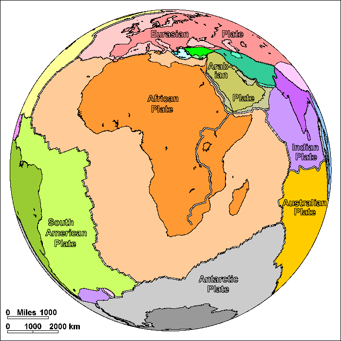
The westerly side is a divergent boundary with the North American Plate to the north and the South American Plate to the south forming the central and southern part of the Mid-Atlantic Ridge. The African plate is bounded on the northeast by the Arabian Plate, the southeast by the Indo-Australian Plate, the north by the Eurasian Plate and the Anatolian Plate, and on the south by the Antarctic Plate. All of these are divergent or spreading boundaries with the exception of the northern boundary with the Eurasian Plate (except for a short segment near the Azores, the Terceira Rift).African Plate
On these diagrams, pairs of parallel lines show boundaries where plates are spreading apart, lines with ticks show boundaries where plates are colliding, and simple lines show other types of boundary. These include places where plates are simply sliding past one another, places where motions are too complex to portray simply, and places where new plate boundaries may be forming.Africa was the center of Pangaea. South America, Antarctica and India broke away from it leaving it surrounded on three sides by divergent plate boundaries. Only on the north is Africa converging on other plates.
The earth has two kinds of crust. The continents are mostly made of thick granite. When continents pull apart, the gap is filled by thin crust made of basalt. In plate tectonics, a continent is any piece of continental crust surrounded by oceanic crust or plate boundaries. Madagascar is a continent. When Africa and eastern Gondwanaland (India, Antarctica and Australia) began to pull apart about 120 million years ago, Madagascar originally moved as part of eastern Gondwanaland. It was originally attached to Kenya, and drifted south until it reached its present location. Then the crust broke on the east side of Madagascar, leaving it attached to the African Plate.
Africa may still be continuing to break up. The East African Rift extends from Ethiopia to southern Africa. The great lakes of Africa owe their long shapes to the rift valley. Rift valley lakes tend to be extremely deep and Lake Tanganyika, at 4000 feet, is the second deepest lake in the world. The rift valley dies out in southern Africa. Some geologists consider the area east of the rift to be a separate plate, others regard Africa as a plate that may be in the process of splitting in two.
The Mediterranean coast of Africa was originally attached to numerous small plates that now make up southern Europe. They broke off beginning about 150 million years ago and collided with Europe beginning about 50 million years ago to create the Alps and other mountain ranges. As Africa moved north, the ocean crust to its north descended into subduction zones. When Africa began to collide with Eurasia, the weight of ocean crust off Arabia pulled Arabia free to open the Red Sea. Up till that time Arabia had been part of Africa. But Arabia itself was already very close to colliding with Iran, so Arabia only moved a short distance before colliding. It may seem odd that Arabia would break apart from Africa only to collide immediately with Iran, but it was the dangling slab of oceanic crust that did it.
Spain is now part of the Eurasian Plate but in the past it has been part of the African and even North American Plates, as well as an independent plate. It has acted much like the pin of a hinge between Eurasia and Africa. About 6 million years ago, Africa collided with Spain to raise a mountain barrier and cut off the Mediterranean from the Atlantic. Since this region is dry, the Mediterranean mostly dried out, covering the floor with salt and gypsum deposits. About 3 million years ago, a river valley cut below the level of the Atlantic and sea water began pouring back in, cutting the Strait of Gibraltar. It probably took many thousands of years to refill the Mediterranean.
One interesting geographic quirk is that Sicily is not part of Europe at all. It is actually a corner of the African Plate.

- East African Plate

- Tectonic_plate_boundaries
No comments:
Post a Comment